Keeler Needle: Harding Route
July 25-27, 2014
Previous Page
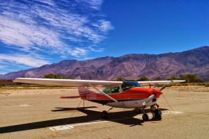 One of the most memorable weekends ever... I flew down to Lone Pine
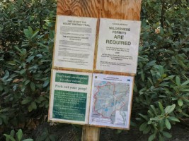
(O26) from Truckee and hitch hiked to the Whitney Portal on Friday.
From there, I hiked in to Iceberg Lake where I met Dow, who was
already up there for a few days climbing routes on Mt Russell.
The forecast for Saturday was good, before thunderstorms were
forecast for Sunday and the rest of the week.
One of the most memorable weekends ever... I flew down to Lone Pine
(O26) from Truckee and hitch hiked to the Whitney Portal on Friday.
From there, I hiked in to Iceberg Lake where I met Dow, who was
already up there for a few days climbing routes on Mt Russell.
The forecast for Saturday was good, before thunderstorms were
forecast for Sunday and the rest of the week.
I was in decent cardio shape from mountain biking but climbing-wise,
I was pretty much off the couch for 2014. The biggest reason was
that for the last several months I was hard at work getting my
pilot license, which was a huge mental energy and time commitment.
Between that and working full time, it was hard to find the time and
desire to climb. Luckily, I passed my checkride just over a month ago!
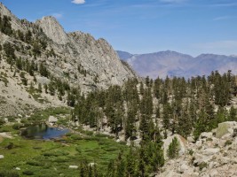
Hiking up to Iceberg Lake, there is a point on which the trail turns
around a corner, and Keeler Needle comes into view - I must admit,
it is highly intimidating of a formation, and completely
breath-taking! The position and height (over 14,000' tall) make this
a sought after Sierra climb. The reputation for quality of the rock
is so-so, but from a distance it looks as good as the Hulk (it's
not, but it's also not horrible). The afternoon heat was quite
draining low down on the trail, but by now it was nice and cool.
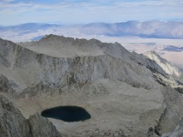
Iceberg Lake sits at 12,600', more than 4000' higher than the
trailhead. Eventually I made it there and found Dow - I showed him
our "post-climb" present that I carried up there - a couple of cans
of Sierra Nevada pale ale that we stashed in the lake to keep cool.
He couldn't believe it... and now that I know how massive the hike
up to Iceberg Lake is, I don't know if I'll do this next time. :-)
The next morning we woke up really early (4:30am?), made breakfast,
and hustled over to the base of the rock to start the climb. Instead
of bringing crampons to go up the snow to the 'start' ledge, we
chose to do a "5.4 loose" approach pitch (also marked on the topo).
After some brief awkward shenanigans putting on rock shoes while
standing on the edge of the ice, I went up to the start. From there,
we roughly did:
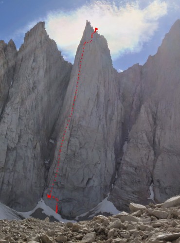
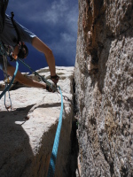
- Pitch 1-2 - link easily with simul climbing for ~30-40' and a
70m rope (there is a lot of easy climbing on these two pitches to
make simul climbing not an issue)
- Pitch 3 - really fun steep double cracks through a
roof to more steep fun climbing.
- Pitch 4 - first OW crux, short but awkward one-move wonder
- Pitch 5/6 - low 5th/4th class wandering to the base of the red
dihedral
- Pitch 7 - the most pleasant pitch of the route, hand jamming in
a beautiful corner for the most part. 230 feet long!
- Pitch 8 - the "sustained" OW. there was a body length of
desperate climbing next to the bolts, but it's well protected with
small/hand sized gear, and a single #4 at the top. Dow is an
offwidth master so he graced up the pitch!
- Pitch 9 - go up a crack right of the chimney. from there, we
went left and up, which was the wrong choice, supposedly there is a
way to traverse right?
- Pitch 10 - we had to do a horizontal traverse with a brief 5.8
section to go around the corner, where you are supposed to be (the
final "headwall"
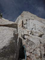
- Pitch 11 - glorious 5.10 crack (or options for easier climbing
around the corner to the right)
- Pitch 12-13 - go more right than you think, and up the easiest
way you can find... eventually passing a memorial plaque (see
photos). The terrain here is confusing, I was sure we were off
route, but we were not...
 From there, we slogged up to the Mt Whitney summit, and dragged
ourselves down the Mountaineers Route (people go up this horrible
thing!? why!?) We were back in camp with plenty of daylight to
spare, and enjoy our Sierra Nevada beers prior to making dinner.
What an awesome adventure of a climb!
From there, we slogged up to the Mt Whitney summit, and dragged
ourselves down the Mountaineers Route (people go up this horrible
thing!? why!?) We were back in camp with plenty of daylight to
spare, and enjoy our Sierra Nevada beers prior to making dinner.
What an awesome adventure of a climb!
One other interesting piece of beta: we carried too much
clothing (I bought an R1 hoody and a nanopuff jacket, one would have
been enough), and for the
entire climb we were sweating bullets and in fact it made it hard to
wear protective clothing through the offwidth... We were both
frustrated with how much stuff we brought, as hauling it up there
made the climbing harder. Of course, it is hard to know, and the
weather could have been different. But in mid-summer, the climb
stays in the sun until 2-3pm, so with an early start, it's possible
to climb without being in the shade (until perhaps the last pitch or
two).
Sunday was another early wake-up, because I was worried about the
arriving thunderstorms (part of a big system over the next several
days), and flying home. It actually rained a bit in the morning as
we were packing up camp... we hustled out of there, and after an
awesome breakfast at the Alabama Hills Cafe in town, Dow dropped me
off at the airport. I was home in Truckee just after noon!
| |
 |
 |
 |
|
| |
Ready to depart Truckee! |
Truckee from the air |
Flying over Lake Tahoe |
| |
 |
 |
 |
|
| |
Over Minden, looking at South Lake |
Desolate terrain to the east, between Minden and Bridgeport |
The Sawtooths |
| |
 |
") |
 |
|
| |
Twin Lakes and the Sawtooths by Bridgeport |
Bridgeport airport (Bryant Field O57) |
Lower and Upper Twin lakes |
| |
 |
 |
 |
|
| |
Off to Mono Lake/Lee Vining next |
Mono Lake |
June Lake |
| |
 |
 |
 |
|
| |
June Lake and highway 395 |
|
Mammoth Airport with Convict Lake in the background |
| |
 |
 |
 |
|
| |
Looking north at Mammoth Mountain ski hill |
|
Bishop airport |
| |
 |
 |
 |
|
| |
|
|
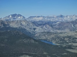
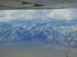
Mt Whitney/Keeler Needle in the background |
| |
 |
 |
 |
|
| |
|
Lunch at the portal store |
What a view on the approach... |
| |
 |
 |
 |
|
| |
|
The amazing thing is, you can see Lone Pine downtown the entire way... |
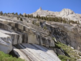
The ledges on the approach |
| |
 |
 |
 |
|
| |
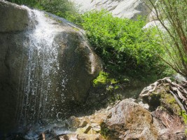
North fork of Lone Pine Creek provides lots of water |
|
Keeler Needle |
| |
 |
") |
 |
|
| |
|
Lots of fish in Lower Boyscout Lake (and also apparently in Upper) |
Lower Boy Scout Lake |
| |
 |
 |
 |
|
| |
Upper Boy Scout lake |
Breath-taking and intimidating view of Keeler Needle from the trail |
Keeler Needle stands proud |
| |
 |
 |
 |
|
| |
Epic sunset from camp |
Our objective at sunset |
Sweet sunrise over the Owens valley |
| |
 |
 |
 |
|
| |
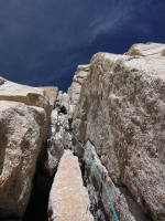
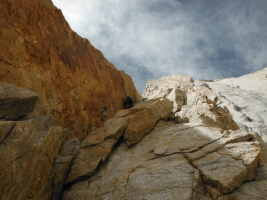
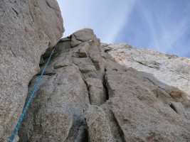
Approaching the start of Keeler Needle |
The junky approach pitch |
First pitch |
| |
 |
 |
 |
|
| |
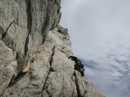
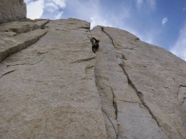
|
Dow coming up the sweet 3rd pitch |
Dow on the 4th pitch |
| |
 |
 |
 |
|
| |
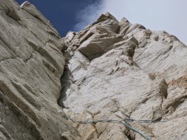
One of the few easier pitches on the route |
Looking at the red dihedral, another great pitch |
|
| |
 |
 |
 |
|
| |
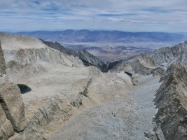
|
|
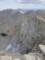
It's a long way down to Lone Pine... |
| |
 |
 |
 |
|
| |
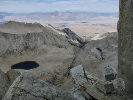
Iceberg Lake where we camped |
Dow leading the offwidth pitch like a champ |
Camp is down there at Iceberg Lake... a long ways away |
| |
 |
 |
 |
|
| |
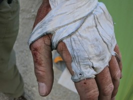
In the offwidth. It's actually not so bad there due to footholds on the right |
|
|
| |
 |
 |
 |
|
| |
5.8 crack to the right of chimney. We got off-route after this, like many other parties it seems |
|
|
| |
 |
 |
 |
|
| |
The last 5.10 pitch, a sweet one |
|
|
| |
 |
 |
 |
|
| |
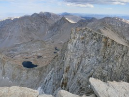
Sketchy blocks on the last "4th class" section |
Story behind the memorial: http://www.mountainproject.com/v/106009337 |
|
| |
 |
 |
 |
|
| |
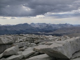
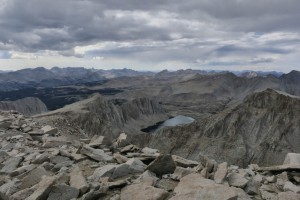
The top! Mt Whitney summit in the background |
Looking down to the west from Whitney |
Threatening clouds |
| |
 |
 |
 |
|
| |
|
Hiking to the summit of Whitney |
|
| |
 |
 |
 |
|
| |
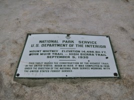
9 lightning rods on the roof... but apparently not enough |
|
|
| |
") |
 |
 |
|
| |
Going down the Mountaineers Route... couldn't ask for anything more fun (not!) |
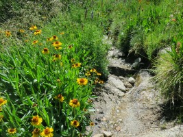
How these flowers grow in such an inhospitable place is beyond me.. |
True survivors |
| |
 |
") |
 |
|
| |
The last gully back to camp |
Icicle! :) |
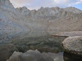
Cool reflection in Iceberg Lake. Calm evening before the storm the next day! |
| |
 |
 |
 |
|
| |
|
|
Sierra Nevada beers I carried up there! |
| |
 |
|
 |
|
| |
Selfie attempt with beers and Keeler Needle in the background |
|
Breakfast at the Alabama Hills Cafe |
| |
") |
 |
 |
|
| |
Dow dropping me off at the airport :) |
Dow loving the airplane idea! |
Meanwhile, hell is about to break loose over Whitney... our timing was perfect |
| |
 |
 |
 |
|
| |
Flying north on the east side of the mountains, with thunderstorms brewing to my lift... perfectly calm flying on my side! |
|
Lee Vining airport below with the edge of Mono Lake... |
| |
 |
 |
 |
|
| |
Lee Vining airport |
Lots of smoke from the new Yosemite fire. |
The Sawtooths with Twin Lakes in the foreground... smoked in |
| |
 |
 |
 |
|
| |
So smokey from the Yosemite and Placerville fires... |
Walker river canyon |
Almost home! Spooner Summit and the east shore of Lake Tahoe |
| |
 |
 |
") |
|
| |
East Shore |
Lake Marlette |
Almost home! One hour and 20 minutes, not bad from Lone Pine :-) |
| |
") |
|
| |
The bird is back in the hangar :) |
Previous Page