Hinchinbrook Island: Thorsborne trail
July 13-16, 2011
Back to Australia 2011 index
Back to homepage
 Janelle recommended this hike (having heard it's amazing from her roommate) and when
reading about it, it was hard not to get excited by it. There were a couple
of problems, though: 1) everywhere we read, there were recommendations to book
a year in advance, since the permits are hard to get - with only 40 people being
allowed on the island at any given time; and 2) cyclone Yasi hit Hinchinbrook
really hard and the trail was still closed when we first heard about it.
Janelle recommended this hike (having heard it's amazing from her roommate) and when
reading about it, it was hard not to get excited by it. There were a couple
of problems, though: 1) everywhere we read, there were recommendations to book
a year in advance, since the permits are hard to get - with only 40 people being
allowed on the island at any given time; and 2) cyclone Yasi hit Hinchinbrook
really hard and the trail was still closed when we first heard about it.
It turned out that due to Yasi, a lot of people understandably cancelled their
plans - but for the last minute travellers like us, that worked out beautifully -
as the trail opened 2-3 weeks before we got there, and there were plenty of
permit spots available! So with a phone call, we booked the island permits and
ferries (which btw, were quite expensive... AUS $90+50+30 each!)
 Cardwell itself was quite depressing, as many houses were heavily damaged,
and left in state of decay - with tarps covering where doors and windows used
to be, walls/roofs missing, etc. The marina from which the ferry usually
left was also completely destroyed, with many of the boats now making up
the graveyard next to it. After some confusion, we found where the boat
takes off in the morning, and all was good.
Cardwell itself was quite depressing, as many houses were heavily damaged,
and left in state of decay - with tarps covering where doors and windows used
to be, walls/roofs missing, etc. The marina from which the ferry usually
left was also completely destroyed, with many of the boats now making up
the graveyard next to it. After some confusion, we found where the boat
takes off in the morning, and all was good.
Day 1
The first day was great! A short walk took us to Ramsay Bay, and after
enjoying the beach we entered the dense rainforest for the next portion
of the hike. At a small side-trail we dropped our packs and managed to do a
hike up to Nina Peak, which gave us fantastic views over the island
including the extensive mangrove forests that it is so famous for!
This little side-trip was my favourite, as the views really opened up,
but we were quite nervous since the trail was fairly overgrown, and
we kept fearing snakes, spiders, and other unfamiliar creates that lurk
in Australian rainforest. We only encountered one dead lizard, and no
threatening creatures - phew. It didn't take long to get to our
campsite at Little Ramsay Bay, and we enjoyed the evening on the beach,
making delicious spaghetti for dinner (everything tastes delicious when
you're hiking!) This was the first time we started worrying about the
saltwater/estuarine crocodiles, since there was a nice lagoon/tidal
creek next to the campsite that I'd really enjoy if I was a croc :)
Day 2
This was supposed to be the hardest day, and took us about 6 hours of
walking, mostly because we didn't want to get our feet dirty in the
swamps, wearing chacos. The swamp itself was fairly easy if you were
careful, and we had to be really careful anyway, due to the excess of
nasty thorny vines called "lawyer canes" - with thorns that easily
ripped through skin or clothing (I escaped with a minor hole in my
tshirt only!) I think in the 'crux' area, it took almost an hour to go
a few hundred meters.
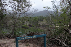
 Once we got to Zoe Bay, it was clear why it is one of the highlights -
the campsites were top notch, very secluded and with picnic tables,
and the beach was gorgeous with interesting tidal 'art' (lines
across the sand), and modern art created by the crabs (see pic).
The weather, however, seemed to be getting progressively worse. It
started sprinkling almost immediately after we got there, and we rushed
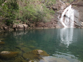
to setup the tent. In a 30 minute pause, we walked up to Zoe Falls,
which had a sweet swimming hole underneath in which we enjoyed a quick
bath (it was cold!)
Once we got to Zoe Bay, it was clear why it is one of the highlights -
the campsites were top notch, very secluded and with picnic tables,
and the beach was gorgeous with interesting tidal 'art' (lines
across the sand), and modern art created by the crabs (see pic).
The weather, however, seemed to be getting progressively worse. It
started sprinkling almost immediately after we got there, and we rushed
to setup the tent. In a 30 minute pause, we walked up to Zoe Falls,
which had a sweet swimming hole underneath in which we enjoyed a quick
bath (it was cold!)
Day 3
 There was no reason to hurry, so we made tea in the morning and
enjoyed watching the tide recede. At around 10am, we started
walking up the trail towards our next destination: Mulligan Falls.
This was perhaps the most beautiful day of hiking - as the trail
first ascends past Zoe Falls, where the views really open up.
You then hike over a pass before eventually descending toward
Mulligan Falls. Unfortunately, we got rained on the whole time, which
was a bit of a bummer, as we didn't see much. As we were setting up the
tent at the campsite it started raining hard, and it rain hard for
about 15 hours, for which we didn't leave the tent (cooking in the
vestibule, etc).
There was no reason to hurry, so we made tea in the morning and
enjoyed watching the tide recede. At around 10am, we started
walking up the trail towards our next destination: Mulligan Falls.
This was perhaps the most beautiful day of hiking - as the trail
first ascends past Zoe Falls, where the views really open up.
You then hike over a pass before eventually descending toward
Mulligan Falls. Unfortunately, we got rained on the whole time, which
was a bit of a bummer, as we didn't see much. As we were setting up the
tent at the campsite it started raining hard, and it rain hard for
about 15 hours, for which we didn't leave the tent (cooking in the
vestibule, etc).
Day 4
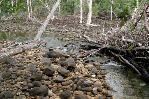
 The first couple of kilometers have about 10 creek crossings, and
then the trail dumps you on the beach. A 5km walk along the beach
eventually reaches George Point, where the ferry picks up. It was
quite overcast, but at least did not rain. The mountains were
engulfed in clouds, however...
The first couple of kilometers have about 10 creek crossings, and
then the trail dumps you on the beach. A 5km walk along the beach
eventually reaches George Point, where the ferry picks up. It was
quite overcast, but at least did not rain. The mountains were
engulfed in clouds, however...
Overall, we had a great time on the island, it was fantastic!
We only saw two other groups in the 4 days we were there...
there were definitely way less than 40 people there - and that
was appreciated. Where else can you do a fantastic hike through
rainforest and beaches, on a secluded island?
Next chapter: Cairns and
surrounding area
| |
 |
 |
 |
|
| |
Leaving Cardwell |
Our home for the next 4 days: Hinchinbrook Island |
The weather isn't looking so hot |
| |
 |
 |
 |
|
| |
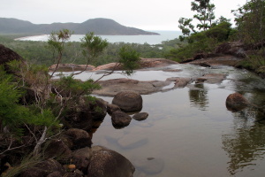
Entering the estuary where we were dropped off, on the north end. Huge mangrove forests and crocodile country! |
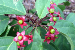
A nice welcome right as you step off the boat. |
No crocs in sight |
| |
 |
 |
 |
|
| |
Starting at beautiful Ramsay Bay |
|
Happy to be in a less toursty part of Australia, finally |
| |
") |
 |
 |
|
| |
The trail is so good, they even built ladders through trees (not sure why it has a reputation of being rough) |
Another small bay that you hike through |
|
| |
") |
 |
 |
|
| |
Hiking up to Nina Peak, there were lots of these (I named them punks) |
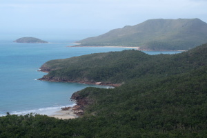
Nina Peak |
View from Nina Peak |
| |
 |
") |
 |
|
| |
|
Ramsay Bay is huge (as seen from Nina Peak) |
The huge mangrove forests on the north end of Hinchinbrook |
| |
 |
 |
 |
|
| |
Another shot of Ramsay Bay |
Beautiful spot |
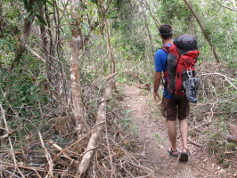
Being dorky on the trail. Note Yasi damage that was recently cleared |
| |
 |
") |
 |
|
| |
|
One of the many creek crossings (easy one) |
|
| |
 |
") |
 |
|
| |
Weird slide marks on the beach. Turtles? |
A small glimpse of sun (note the building up of storm clouds) |
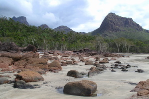
We hardly saw the bigger mountains, constantly engulfed in clouds |
| |
|
 |
 |
|
| |
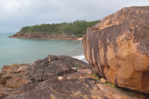
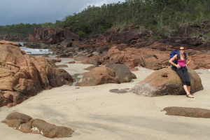
Lovely! |
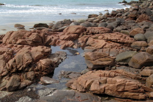
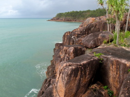
Such pretty red rocks |
|
| |
") |
 |
 |
|
| |
Another hour, another beach :) |
Remnants of the tide |
Chef Peter: Spaghetti marinara |
| |
 |
 |
") |
|
| |
Camp for night 1 |
|
The lagoon next to Little Ramsay Bay (fresh water a little higher up the creek) |
| |
 |
 Name: lawyer cane") |
 |
|
| |
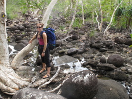
The first little swamp - straightforward |
These little hooks were very evil (one ripped a hole in my shirt the next day!) Name: lawyer cane |
Damage from Yasi is extensive throughout the island but the trail is cleared |
| |
 |
") |
 |
|
| |
More damage and fresh clearing |
Another little swamp. Managed to cross all with dry feet after tip toeing :) |
Strange growth on some trees |
| |
 |
 |
 |
|
| |
You have to wade the creek here to make it across the trail, but there is a croc sign? Hmm |
No crocs today... |
|
| |
 |
 |
 |
|
| |
|
Fresh tree ladder on a Yasi-striken tree. Better quality than most urban stairs! |
The crux swamp |
| |
, waiting to get you if you are not paying attention") |
 |
 |
|
| |
More hookies (as we named them), waiting to get you if you are not paying attention |
Another creek |
Very extensive root system! |
| |
 |
 |
 |
|
| |
Swampy |
But he seems happy in that environment |
Zoe Bay, our next campsite. Perhaps the best one! At low tide... |
| |
 |
 |
|
|
| |
We're here! |
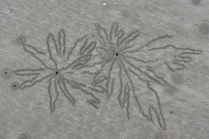
Beautiful art created by the local crabs! |
Quite unbelievable. Those were everywhere... |
| |
 |
 |
|
|
| |
For scale |
Note the 'rat box' in the background - the equivalent to the bear boxes we are used to |
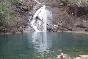
Zoe Falls - a beautiful swimming hole that we deemed safe from crocs (due to large rocky drops after it) |
| |
 |
") |
 |
|
| |
|
We camped in this little alcove (high tide reaches past where I'm sitting) |
The ripples in the sand created by the tide are quite neat |
| |
 |
 |
 |
|
| |
Campsite with morning tea |
The weather looks gloomy, and it was... it ended up drizzling all day, and raining hard for 12+ hours after that |
Fancy campsite, with even a picnic table! |
| |
 |
 |
 |
|
| |
Our condo for the 3 nights |
No clue what this bone was from... but it was big |
One last departing shot of Zoe Bay: eventually we had to leave! |
| |
 |
 |
 |
|
| |
Luxury |
|
The trail climbs above Zoe Falls |
| |
 |
 |
") |
|
| |
And the views open up! |
The beginning of Zoe Falls |
Almost postcard (if the weather would be a little brighter...) |
| |
 |
|
 |
|
| |
Infinity pool? |
|
Then the trail climbs up to a saddle. And it started raining... |
| |
 |
 |
 |
|
| |
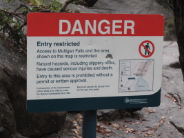
They are so cautious in Australia! |
Just in case you were tempted. |
|
| |
") |
 |
 |
|
| |
Mulligan Falls (in the rain) |
Mulligan Falls |
Our campsite after a miserable afternoon/night of constant rain. Thankfully it stopped in the morning! |
| |
 |
 |
 |
|
| |
On the last day, you cross 5 creeks in only 1km! |
Creek crossing in action |
The last stretch is very easy 5km along the beach to George Point, where the southern ferry picks you up. Gloomy weather! |
| |
 We had to wait over an hour for the tide to drop enough for us to be able to cross.") |
 |
") |
|
| |
Looking for crocs.. not very croc wise :) We had to wait over an hour for the tide to drop enough for us to be able to cross. |
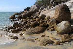
The last crossing. From here, it's only 2km to the very pick-up point. |
We got really unlucky with the weather, as mentioned (being dry season!) |
| |
 |
 |
. It was just us and Michael from Quebec City (living in Townsville)") |
|
| |
Funky tree |
Interesting jellyfish? Or something similar washed on the beach |
George Point (note the ferry symbol, he he). It was just us and Michael from Quebec City (living in Townsville) |
| |
 |
") |
 |
|
| |
In case you forgot where you were... |
Our boat that took us to Lucinda (and then bus transfer back to Cardwell) |
There are only about 1,000 cassowaries in the wild apparently, so don't run one over! |
| |
 |
 |
|
| |
There were a lot of signs like this near Mission Beach |
Hinchinbrook Island: Thorsborne trail map |
Previous Page