Mt Conness SW Face (Harding Route, 5.10c)
July 26, 2015
Previous Page
 Dow and I did our annual climbing trip and we picked Mt Conness.
Like last year's
Keeler Needle,
I was basically off the couch, with less than one climbing day per
month this summer... things have been busy! The occasional hour or two of
mountain biking is all I had in terms of "training". But I was really
excited to climb and that's more important, right?
Dow and I did our annual climbing trip and we picked Mt Conness.
Like last year's
Keeler Needle,
I was basically off the couch, with less than one climbing day per
month this summer... things have been busy! The occasional hour or two of
mountain biking is all I had in terms of "training". But I was really
excited to climb and that's more important, right?
I made a huge pancake breakfast on Saturday morning at home (blueberries,
chocolate chips AND bananas, in each pancake!), and in the early
afternoon I flew south to Lee Vining, where Dow graciously offered to pick
me up from the airport after he drove there from St George. I showed up a
bit early so I walked over to the Whoa Nellie where I had a phenomenal
lunch (mm, food) and relaxed before he showed up. I was glad Dow didn't get
lost in a bar in Tonopah! Our plan was to hike in halfway the evening
before, so we can sleep a bit longer and get an early start on Sunday. I
was supposed to be at work in Mountain View on Monday morning - no time to
waste!
 We started hiking in the early evening, and everything seemed to be
perfectly clicking into place. I had done the hike in before with
my friend Pavel, so I knew the approach - or, more accurately, I should
have known where the approach is. Because of the fact I had done it
before, I was fairly complacent, and we were chatting, having a great time,
completely forgetting we have to make a right turn and go off-trail towards
the 3rd class ledges/cliff bands. I did remember having to go over 3rd
class ledges, and I commented to Dow at one point that the approach is much
more straightforward than I remembered - great news! Or not. Well,
eventually we ended up almost at the top of the ridge, having gained
several thousand feet, when I suddenly looked around and realized we're
completely in the wrong place! I didn't know whether to laugh or cry - our
legs were already feeling tired, and we had totally messed up the approach.
We could have tried to do some shenanigans and traverse the ridge, but it
was unknown whether that would work - so we decided it's safer to retreat
back down and go up the correct gully. We didn't lose all the elevation and
were able to traverse around eventually, but the whole thing definitely
cost us a couple of hours and a whole bunch of energy. Anyway, eventually
we made it to the top of the cliff bands and since it was getting dark,
elected to just bivy there (an hour from the car, after 3 hours of
hiking... sigh)
We started hiking in the early evening, and everything seemed to be
perfectly clicking into place. I had done the hike in before with
my friend Pavel, so I knew the approach - or, more accurately, I should
have known where the approach is. Because of the fact I had done it
before, I was fairly complacent, and we were chatting, having a great time,
completely forgetting we have to make a right turn and go off-trail towards
the 3rd class ledges/cliff bands. I did remember having to go over 3rd
class ledges, and I commented to Dow at one point that the approach is much
more straightforward than I remembered - great news! Or not. Well,
eventually we ended up almost at the top of the ridge, having gained
several thousand feet, when I suddenly looked around and realized we're
completely in the wrong place! I didn't know whether to laugh or cry - our
legs were already feeling tired, and we had totally messed up the approach.
We could have tried to do some shenanigans and traverse the ridge, but it
was unknown whether that would work - so we decided it's safer to retreat
back down and go up the correct gully. We didn't lose all the elevation and
were able to traverse around eventually, but the whole thing definitely
cost us a couple of hours and a whole bunch of energy. Anyway, eventually
we made it to the top of the cliff bands and since it was getting dark,
elected to just bivy there (an hour from the car, after 3 hours of
hiking... sigh)

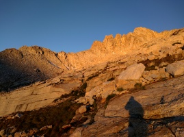
The sunrise was gorgeous! For some reason it was windy all night and
windy in the morning, so it was pretty cold. We made it to the top
of the ridge/summit plateau and hung out there for a little while
sorting out gear and finding a place to leave our packs. We went down
to the descent gully (which isn't that hard to find, the first couple of
gullies look suicidal, it's the first reasonable-looking one, and the
first one from which you can see the entire face - btw, great approach
beta on Luke's page here) and it looked
shady and cold down below! We debated whether to hang out on top until
the sun came around enough, but eventually we realized the sun isn't
going to hit the wall until 10am this time of year. So we reluctantly
made our way down and started climbing around 9am. I guess that's why it
makes more sense to just hike in car-to-car - the bivy is pointless. Dow
battled the first wet pitch for over an hour - it was horrible and sketchy,
running with water, covered in slime making it impossible to get any
friction. He did a fantastic job getting us up there - I would have just
bailed in frustration (though there's a dry variation to the right
apparently). Anyway, I'll just skip talking more about it - the second
pitch was, in contrast, quite amazing, if a bit sustained! The other
stand-out pitches were of course the offwidth pitch - which was definitely
burly and Dow did a great job leading it, with me barely surviving on
second - and the one after - the 5.10 traverse isn't the crux, it was the
5.8 squeeze chimney at the top which felt just as difficult as the 5.10
offwidth. I read on summitpost that Pavel felt the same way. I made the
mistake of leaving the #6 at the belay (we carried it for the offwidth
pitch) - it would have been handy to protect it! After that was over, a
couple of more straightforward pitches lead to 3rd class, and then the top.
 The descent went pretty quickly, though we missed the Whoa Nellie Deli's
dinner due to our slow speed - bummer! Should have climbed quicker, but it
was not in the cards that day :) In retrospect, we both felt Keeler Needle
was quite a bit easier, which is funny because the supertopo guidebook
tells you to climb Conness to prepare for Keeler. I suppose it's all
relative :)
The descent went pretty quickly, though we missed the Whoa Nellie Deli's
dinner due to our slow speed - bummer! Should have climbed quicker, but it
was not in the cards that day :) In retrospect, we both felt Keeler Needle
was quite a bit easier, which is funny because the supertopo guidebook
tells you to climb Conness to prepare for Keeler. I suppose it's all
relative :)
It was hard to sleep during the night because it was super windy, gusting
to 30-40mph from the west. I was nervous about flying in the morning (I'd
be grounded if that wind kept up), but thankfully it did calm down. We had
breakfast at the Whoa Nellie (almost as good as the dinner?), Dow and I
said our goodbyes (he was going to climb the rest of the week in Tuolumne),
and then I took off around 8am. I flew right over Mt Conness to check out
the SW face, and then along the Grand Canyon of the Tuolumne river and
Hetch Hetchy. At my desk after showering at 10am... not bad. I'm not sure
what I enjoyed more - the climb or the flight over the Sierra! :) It was
certainly easier to take pictures during the latter. Though like the
climb, the flight felt serious, with lots of inhospitable terrain and
very few good emergency landing zones (after all, that's why as climbers,
we love the Sierra - it's very rocky!)
| |
 |
 |
 |
|
| |
Departing from Truckee towards Lee Vining |
Big blue |
Marlette Lake |
| |
 |
") |
 |
|
| |
Kingsbury grade |
Minden (including airport bottom left) |
Bridgeport Lake/valley |
| |
 |
 |
 |
|
| |
|
Bridgeport |
Twin Lakes near Bridgeport, gorgeous area |
| |
 |
 |
 |
|
| |
Virginia Lake in the distance |
Lundy Lake |
Mono Lake |
| |
 |
 |
 |
|
| |
Tioga Pass |
|
Mono Lake, with Lee Vining airport. Gorgeous place! |
| |
 |
 |
 |
|
| |
The crazy color of Mono Lake |
|
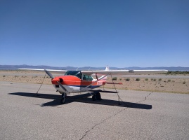
Stanley tied down and ready for a rest day, while I go climbing with Dow |
| |
 |
 |
 |
|
| |
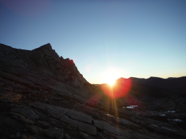
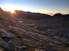
Gorgeous sunrise |
Sunrise! |
|
| |
 |
 |
 |
|
| |
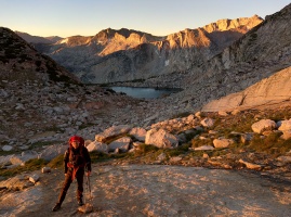
It was pretty cold before the sun came out! |
|
At the top of the summit plateau |
| |
 |
 |
 |
|
| |
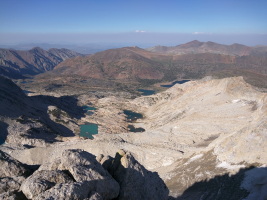
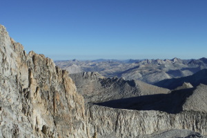
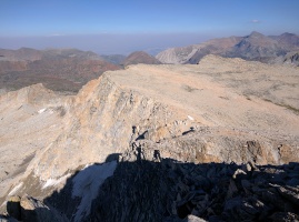
The entire SW face, as seen from the correct descent gully |
|
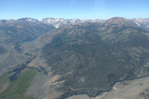
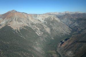
View towards the meadows and valley. Lots of smoke down there! |
| |
 |
 |
 |
|
| |
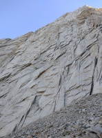
Donald Goodrich memorial. He died from rockfall on the first ascent attempt. |
Dow at the start of the climb. The first pitch was horribly wet and took us almost 2 hours. A better way is to climb dry rock on the right. |
|
| |
") |
 |
 |
|
| |
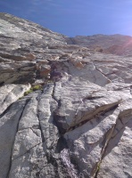
Starting the second pitch (technical crux) |
Dow on the second pitch - 5.10c |
|
| |
 |
 |
 |
|
| |
The top of the 5.10c |
Looking towards the descent gully |
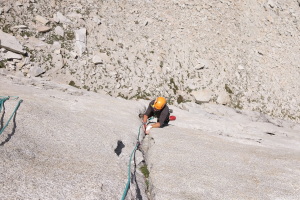
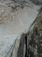
The offwidth pitch - the physical crux of the route |
| |
 |
 |
 |
|
| |
The offwidth pitch - the definite physical crux for most |
|
|
| |
 |
 |
 |
|
| |
5.10b traverse pitch after the offwidth pitch. The 5.8 squeeze chimney at the end was a bit of a surprise |
Getting into the squeeze chimney at the top of the last 5.10 pitch |
Dow starts the second to last pitch |
| |
 |
 |
") |
|
| |
|
Pitches 8 & 9 - 5.8 stem, to a 3rd class ramp, to a short 5.9 finish |
The final difficulty (short 5.9) |
| |
 |
 |
 |
|
| |
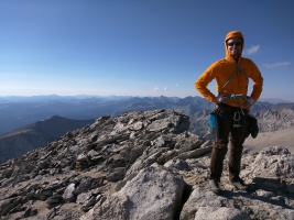
At the top of the technical difficulties - so happy! |
Looking towards Tuolumne Meadows. Fairview Dome looks tiny! |
|
| |
 |
 |
 |
|
| |
Excited to be on top! |
Descending the 3rd class ledges on the approach |
Gorgeous light as we hike back to the car |
| |
 |
") |
 |
|
| |
Sunrise at Lee Vining airport with Mono Lake in the background. We had breakfast at the Whoa Nellie and I took off at 8am. |
Transferring the gear :) |
Dow dropping me off at the airport |
| |
 |
") |
 |
|
| |
Departing Lee Vining over Mono Lake. Doesn't get much more beautiful than this!!! |
Grant Lake (and June Lake behind it, not seen) |
Mono Lake and the Lee Vining airstrip as seen from several thousand feet above. |
| |
 |
") |
 |
|
| |
|
Mt Dana and the Third Pillar of Dana where Melissa and I got engaged :) |
The Tioga pass road, and Ellery Lake. Have driven this so many times! |
| |
 |
 |
 |
|
| |
Another look at Mt Dana and the plateau |
Looking towards the meadows |
Young Lakes |
| |
 |
 |
 |
|
| |
|
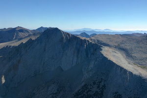
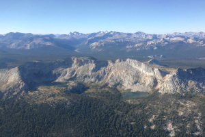
Mt Conness SW face in full view. |
Rough outline of the Conness SW Face route. |
| |
 |
 |
 |
|
| |
|
Flying towards Pine Mountain Lake. Rocky inhospitable terrain... |
The upper part of the Grand Canyon of the Tuolumne |
| |
 |
 |
 |
|
| |
Lots of walls to climb back here - but how do you get there? |
Over Hetch Hetchy. One of the best options in case of emergency I suppose... |
Fire damage |
| |
 |
 - Groveland, CA") |
|
| |
Bird's eye view of the Yosemite Rim fire |
E45 - Pine Mountain Lake airport (with the namesake lake!) - Groveland, CA |
Previous Page